Place: Tulagi
Details
Tulagi Island, in the Nggela Islands, was the administrative capital of the British Solomon Islands Protectorate from 1897 until 1942. In the local Vavaea language, lagi means 'to throw' and tu means 'to put a foot forward' and the name seems to have come from a descent group that lives in the area. The small island was the official port of entry, the home of the Resident Commissioners, and along with neighbouring Gavutu-Tanambogo and Makambo Islands, the Protectorate's main commercial base. There were also Chinese traders in Tulagi's Chinatown. The main shipping was by several small trading ships, some of them run by Chinese, which travelled from island to island, and the various recruiting ships run by Europeans. The main facilities of the Protectorate were in Tulagi: the courthouse, prison, post office and the government hospital.
The first Resident Commissioner, Charles Woodford (q.v.), took up residence on Tulagi in 1897. On 29 September 1896 Woodford paid Tambokoro and other owners £42 in gold sovereigns to buy the island for the new Protectorate Government-Tambokoro and his sons took £12, while the inhabitants of Matanibana, Haleta, and Tugumata villages received £10 per village. The island up to then had been used only for gardening, and Woodford misled the villagers by assuring them that their garden rights would not be disturbed.
The first two buildings were almost completed by November 1897 and the police quarters were finished in March 1898. Woodford had also had bananas and sweet potato planted. (AR 1897-1898, 12, AR 1901-1902, 18) All of the police were able to relocate to Tulagi on 16 August, and by the time the carpenters left at the end of November the first Residency, prison and road were practically complete and a permanent water supply had been installed. The prison and the small police headquarters built in 1898 were a useful advance; when Woodford had brought prisoners back from Guadalcanal in September 1897 he had to chain them to house posts. (Boutilier 1984b, 47) Between December and January tracks were improved, gardens were planted and the building of a permanent police headquarters was underway (completed in March). During 1898-1899, a house was constructed for Woodford's assistant, the Protectorate's first District Officer Arthur Mahaffy, and general improvements were made by draining swamps and planting coconut trees, root crops, and other experimental tropical crops such as cocoa, rubber and coffee. Around twenty-four hectares were under cultivation, which by 1901 had expanded to forty hectares, including thirty of coconut palms. Woodford continued to have all swampy areas filled, aware that this reduced the incidence of malaria. Two years later, sixty hectares were under cultivation, fifty-four of them coconuts palms. The Residency was linked to the landing place by concrete and stone stairs, which are all that remains of the Residency today aside from a couple of concrete posts. Later photographs indicate that the coconut plantations continued to increase in size. The nuts were used for food and commercial purposes. The inner foreshore of the town became a pleasant promenade and transport route. ('New Guinea and the Solomons: Their Future Development. Senator Staniforth Smith's Views', Daily Mail (Brisbane), 4 Jan. 1905, cutting in Woodford Papers, reel 2, bundle 8, 9/23, enclosed in 8.3, PAMBU; AR 1897-1898, 12-13, AR 1898-1899, 14-15, AR 1899-1900, 13, AR 1900-1901, 16, AR 1901-1902, 18-9, AR 1902-1903, 21)
Initially, shipping communication was via the SS Titus, which called every two months at Norfolk Island, Port Vila, the Santa Cruz Islands and Tulagi. Woodford was critical of this route, which took three weeks when a direct Sydney-Tulagi trip only took eight days and would allow tropical produce to reach Australian markets. In 1900, Burns Philp & Co. (q.v.) steamers established regular shipping to and from Sydney. Burns Philp & Co. received a subsidy from the Australian government for its shipping service, but they still claimed to be operating at a loss due to the circuitous route. Only the passenger and cargo traffic to Tulagi was profitable, which indicates its volume. (AR 1926-1927, 8) By the 1910s, communications had improved: Burns Philp & Co. ran a direct steamer service from Sydney to Tulagi every six weeks, and their Gilbert and Ellice Islands steamer called in for mail on its way to and from Australia. Lever's Pacific Plantations Ltd. (q.v.) steamer SS Upolu called every eleven weeks, and they also operated two small steamers within the Protectorate. (AR 1902-1903, 17, AR 1912-1913, 8) All overseas ships were boarded upon arrival by Tulagi-based officials who carried out medical checks on passengers and crews. They would then amble over to Gavutu or Makambo to unload at their respective company headquarters before setting off around the Protectorate. From 1903 labour trade vessels from Queensland and Fiji had to call at Tulagi before discharging their human cargoes or commencing recruiting. Twenty-three plantation companies were then operating in the Protectorate, using smaller craft that called at Tulagi.
The shipping services allowed direct communication with Sydney twenty times each year. Internally, beginning in 1899, the Protectorate had its own vessel, the yacht Lahloo (q.v.), which Woodford used on patrol and to communicate with his deputy Mahaffy once Mahaffy opened a base in Gizo. In later years, a series of small vessels served the districts and the Resident Commissioner used the handsome Tulagi. It was the largest government ship but was unstable in bad weather. Gavutu was central to replenishing coal supplies of ships, the coal being placed into baskets and wheeled down to the wharf on a rail track. (Sinker 1900, 42-43; Horton 1965, 21-22)
As the 1900s progressed, Tulagi developed the standard trappings of an isolated colonial outpost. Throughout the 1910s and 1920s, its swamps continued to be drained and low-lying areas were reclaimed, which eradicated most mosquito breeding places and made the island a healthier place. Sanitation was also improved by building proper latrines for use by indentured labourers, police and prisoners, and incinerators were established to destroy empty tins and refuse. The hospital was opened in 1914, initially only to Europeans, although a ward for Solomon Islander patients was added in the same year and expanded in 1920-1921. Also added was an isolation ward, which was converted in 1926 for use by Asians. In another health measure, in 1928 a quarantine station was established on an adjacent island and four new isolation wards for infectious cases were built at Tulagi hospital. (WPHC no. 2954 of 1926, C. M. Woodford to WPHC, 21 Feb., 3 Apr. 1914, WPCH to R. R. Kane, 15 Oct. 1926, N. Crichlow to Government Secretary, 27 May 1926; and WPHC no. 800 of 1914, S.C.M. Davies to Woodford, 16 Feb. 1914)
A new Residency, prefabricated in Sydney, was erected in 1905 near the first primitive house. The second Residency was single-storey with deep verandas in colonial Australian style. Once this was ready, the first Residency was allocated to the Treasurer until a new house was built for him on the same site in 1914. In the 1900s, the town grew to around twenty residents, with others on Makambo and Gavutu. Stanley G. C. Knibbs arrived in 1912 to become the Government Surveyor. In the 1910s, several stores developed to trade directly with the Solomon Islands labourers who passed through on their way to or from plantations. The Chinese who came to work in the Protectorate were quick to start trading ventures and a small Chinatown soon sprang up next to the administrative centre. Woodford remained Resident Commissioner until January 1915 when he retired after twenty-nine year's association with the Solomon Islands. He was replaced by Frederick Joshua Barnett (1915-1917) (q.v.), Woodford's assistant (1908-1914) and Treasurer and Collector of Customs (1914-1915). Barnett left in 1918, and Charles H. Workman (q.v.) was appointed Acting Resident Commissioner in 1917, and continued on a full appointment from 1918 until 1921 when the next permanent appointment was made to Richard Rutledge Kane (q.v.), who had been the BSIP Government Secretary. Kane served until October 1928, when he took his final leave and retired. The position was taken over in an acting capacity by Captain N.S.B. Kidson, the Government Secretary, then by District Officer Jack C. Barley and then Ralph B. Hill until the arrival of Francis Noel Ashley (q.v.) in 1929. Ashley, who had previously served in Africa, remained until 1939, when he was replaced by William S. Marchant (q.v.), who left in 1943 during the Second World War.
Under the Resident Commissioners was a strictly ordered hierarchy of officials, with their relative importance expressed in their houses' sizes and positions on the ridges. Most senior were the Government Secretary, the Chief Magistrate, the Treasurer and Collector of Customs, and the Commissioner of Lands and Crown Surveyor. The first Chief Magistrate and Legal Adviser to the Protectorate, twenty-six-year-old Issac Grainger Bates, was appointed in 1913 and remained until 1923. He was replaced in 1924 by the incompetent N.W.P. de Heveningham, who stayed until 1928. The next Chief Magistrate was P. C. Hubbard, who began as a Cadet in 1928, took over the position in 1930, and stayed for four years. The post was left vacant during the Depression from 1934 until 1937, when D. R. McDonald filled it for a year. The last prewar incumbent was Ragnar Hyne, the former Chief Justice of Tonga. (Boutilier 1984b, 44) Frederick E. Johnson (q.v.), the able Treasurer and Collector of Customs (1919-1947), acted as Resident Commissioner for periods of 1938, 1939, 1941, and was in that position when the Japanese invaded in 1942. 'Pop' Johnson, born in 1878, had previously worked in the New Hebrides (1904-1919) and was the longest-serving member of the early Administration. He ran the BSIP administration in Sydney from 1942 to 1946. (Golden 1993, 95-96) Two other fixtures were S.G.C. Knibbs and Alexander 'Spearline' Wilson. Knibbs, mentioned above, held a series of posts: Government Surveyor (1913-1924), Commissioner of Lands and Crown Surveyor (1924-1939), acting Superintendant of Public Works (1918-1939), Registrar of Land Titles (1919-1939), and Chairman of the Mining Board (1927-1939). Wilson served the Protectorate from 1919 to 1942 as a surveyor (1919-1924), Government Surveyor (1924-1939) and Commissioner of Lands and Public Works, and Registrar of Land Titles and Chairman of the Mining Board (1939-1942). (Wilson 1946)
Tulagi, or New Florida as it was sometimes called, faced onto an extensive harbour. The protected waterway between the island and the mainland extended east to Gavutu Harbour, with easy access to Port Purvis and the narrow Mboli Passage between Gela Sule and Gela Pile through to the Anglican headquarters at Siota. In 1907, Levers Pacific Plantations Ltd. Purchased Svensen's (q.v.) Gavutu Island as their depot, and in 1908 Burns Philp & Co. purchased small Makambo Island, opposite Tulagi but closer to the mainland. A photograph from circa 1909 shows the beginnings of the Makambo settlement. (Golden 1993, 68-69, 416) Martin and Osa Johnson's 1917 film shows Makambo with substantial development. Levers later built a causeway to link Gavutu to close-by Tanambogo, creating an excellent port facility. Most overseas arrivals were via a series of Burns Philp & Co. steamers, first the SS Titus and then the larger SS Mataram, and over years the successors SS Makambo, SS Marsina and SS Malaita. Makambo had large retail and bulk stores, an insurance agency, staff quarters and a substantial manager's residence, but never a large wharf. Photographic evidence suggests that large vessels either anchored offshore and used lighters to ferry cargo and passengers, or used Levers' substantial concrete wharf at Gavutu if they needed to berth. From 1905 until 1916, Levers operated their own overseas steamers, SS Upolu and SS Kulambangara, which berthed at Gavutu. After Gavutu, the overseas steamers proceeded north as far as the Shortland Islands, calling at several ports, collecting freight and delivering cargo over a two-week period before returning to the capital. W. R. Carpenters & Co. also operated an intermittent steamer service via New Guinea, using SS Inga to call at Tulagi and Vanikolo on the way back to Australia. Norwegian, Swedish, Japanese and U.S. steamers also called to collect copra. Internal Protectorate communications were maintained by the government vessel Ranadi (q.v.), Burns Philp's SS Malaita, Lever's motor vessel Koonookarra and Carpenter's Duranbah, all of which regularly called at Tulagi, Makambo and Gavutu. (AR 1928, 9, AR 1929, 8)
Makambo and Gavutu
Merchant companies such as Australian companies Burns Philp & Co., W. R. Carpenter & Co., Morris Hedstrom Ltd. From Fiji, and several Chinese companies provided early commercial services, including banking and credit facilities, but only for foreigners. Sometimes Solomon Islanders could gain credit facilities through traders. However, they were protected by Native Contracts' Regulation No. 2 of 1896 under which no civil action could be taken to recover debts from Solomon Islanders, and hence the government discouraged such advances. Solomon Islanders also often refused to recognise debts when one company representative was replaced by another, which meant that it was safer to refuse any credit. Only mixed-race Solomon Islanders had reasonably secure access to limited credit. Between 1918 and 1937, the Protectorate issued its own paper currency to supplement the gold coins and Australian Commonwealth bank notes in circulation. From 1919, this local currency was also used to pay labour, with £4,154 in circulation that year. (AR 1917-1918, 5, AR 1918-1919, 4) District Officers also served as postmasters, and from the 1920s ran a money order service through the Commonwealth Bank of Australia, which enabled money to be remitted throughout the world. Even so, most large transactions were carried out in Tulagi where Burns Philp & Co. managed the agency. (AR 1922-1923, 6)
Chinatown
The first Chinese tradesmen seem to have reached the Protectorate in 1910. By 1913, Ah Choi had applied for a land lease on Kokona Island in the Nggela Islands, and in 1914 Kwong Cheong had a trading business at Tulagi. They probably came south from Rabaul, where the Germans had allowed Chinese immigration. (In 1914 around 1,000 Chinese lived in or near Rabaul.) In 1918, there were sixty-one Chinese in the Protectorate, the majority on Tulagi, attracted by trade with time-expired labourers when they were paid off. A few (four in 1934) worked as mechanics and carpenters in government service. (AR 1934, 13) Chinese stores were beginning to provide the necessities of life, and a Chinatown developed on reclaimed mangrove swamps on the edge of the government centre. In 1917, the American visitor Osa Johnson did nearly all of her shopping at one of the Chinese stores, 'which had everything from fish and vegetables and dry goods and hardware'. (Johnson 1945, 111-112)
Tulagi's Chinatown was well established by the late 1920s and had grown to such an extent that in 1929 the Lands Department surveyed it and imposed a street plan. (AR 1929, 12; Knibbs 1929, 264) There are several good photographs of Chinatown that show its extent and complexity. In the 1930s, it was replete with trade stores and eating places, and when Saturday became the regular market day on the nearby shore, swarms of canoes brought produce to sell. (Knibbs 1929, 274; Godfrey 1928, 6) Smart Chinese traders turned up their gramophones to attract customers to buy their enticing wares. They also let off firecrackers and lit their premises with colourful paraffin lamps, particularly to celebrate the Chinese New Year. (Knibbs 1929, 275)
A branch of Chiang Kai-shek's Chinese Nationalist Party, the Kuomintang, had its own premises on Tulagi. Although many Chinese were single men, there was a nucleus of married couples and a few children. Chinese were also allowed to set up stores on Isabel, at Gizo and in the Shortlands in the north, and at Auki on Malaita. The Protectorate Chinese community slowly increased: from 55 in 1920, to 90 in 1925, 164 in 1931 and 193 in 1933. Most stayed only for the duration of their contracts but some used their savings and connections in Rabaul, Hong Kong and Sydney to import trade goods and establish stores. (Laracy 1974, 29; Resident Commissioner C. M. Woodford to District Officer T. W. Edge-Partington, 24 Dec. 1911, BSIP 14/6; District Officer W. R. Bell to Resident Commissioner, 12 June 1927, BSIP 14/60)
Chinese also operated ships on trading circuits around the Protectorate. A 1930s photograph shows seven rickety jetties in Chinatown, an indication of the network of Chinese traders that existed, and the centrality of the Chinese community to commerce. Chinese numbers had dropped to 180 by 1941, probably because the administration tried to tighten entry requirements in the 1920s and early 1930s. The Hong Kong government did not issue passports and they were difficult to obtain in China. The Resident Commissioner had complete control of all entries without passports and in 1928 a new regulation levied a bond of not less than £20 on jobless immigrants. Restrictions were increased the next year, but most restraints on Chinese were lifted in 1933, although they were still forbidden to obtain freehold land. The major merchant companies-Carpenters, Burns Philp and Levers-did not want competition from Chinese merchants and raised the usual complaints about their corrupting influence on the natives through gambling, alcohol and vice. (Wilson, Moore and Munro 1990, 98-99; Laracy 1974; Bennett 1987, 152, 206, 208-209, 216, 224-25, 230, 236, 237-38, 249, 250, 252, 253, 254, 256, 268, 269, 271, 288, 319, 330) Asians outnumbered Europeans on Tulagi by about four to one, and were central to the retail end of commerce in the Protectorate, although they were always marginalised in other ways. Europeans appreciated their tradesman skills but cursed their entrepreneurial flair; Solomon Islanders availed themselves of the cheap goods sold in their trade stores.
Solomon Islanders at Tulagi
From the early 1920s all indentured labourers had to go to Tulagi to sign off at the Labour Department. This meant that around thirty-eight thousand final wages passed to the local traders in return for trade goods, a remarkably lucrative process for the large merchant companies and Chinese businesses. From about 1914, Levers and Burns Philp operated trade stores at their labour transit depots at Gavutu and Makambo, while Carpenters and Morris Hedstrom had direct access to labourers singing-off at Tulagi, as did the Chinese stores. (Bennett 1993, 148)
The Japanese Invasion
In 1939, alarmed by the deteriorating situation in Europe, Resident Commissioner Noel began to prepare for invasion and formed the British Solomon Islands Defence Force, with G.E.D. Sandars (q.v.) as its Commanding Officer and David Trench (q.v.) and Martin Clemens as his deputies. Prisoners helped build a maze of trenches and gun sites and squads were trained, including a Chinese squad. (Horton 1965, 127) In preparation for the upcoming war, Gavutu-Tanambogo became an Australian naval base, a side-product of which was photographs of Tulagi Harbour and probably the first aerial photo of Gavutu-Tanambogo, showing the causeway joining the two and the full extent of Levers' commercial development of the complex. Early in 1941, an Australian Air Force Patrol Base was established at Tulagi, and in November nineteen Australian soldiers arrived to help train the Defence Force, but the idea was never carried forward. Evacuation of Tulagi began in late December 1941, first the women and children, followed by government and commercial companies staff and equipment. (Baddeley 1942) The Japanese first bombed Tulagi on 22-23 January 1942, and continued bombing there, Makambo and Gavutu-Tanambogo through March and April, forcing a hurried evacuation. The attack concentrated on Tulagi and the antiquated radio station and ignored the Australian Air Force station recently established on Tanambogo. Resident Commissioner William Marchant withdrew the administration to Auki, Malaita, although the R.A.A.F. base at Gavutu-Tanambogo continued to operate until it was abandoned on 1 May. The Japanese 3rd Kure Special Naval Landing Force captured Tulagi without resistance on 3 May and established a Japanese seaplane base at the R.A.A.F. facilities. (Trench 1956; Archives, in Australian National University Noel Butlin Archives, N115-250, Kenneth H. D. Hay to Chairman of Directors, Burns Philp (South Seas) Co. Ltd., 7 Feb. 1942, Burns Philp & Co.) The base was obliterated by American retaliatory raids on 7-8 August, which forced out the Japanese, who had dug tunnels into the higher reaches of Tulagi and Gavutu.
Ironically, the aerial photographs of Tulagi taken by Australian defence forces just before the war and photographs of Tulagi, Makambo and Gavutu-Tanambogo under bombardment are some of the best ever taken of the four small islands at the core of the Protectorate. War photography also reveals many details about Tulagi unavailable from written records. By late 1942, many tracks criss-crossed the small island and extensive clearing and reclamation had been done to create facilities on the opposite side of the island accessed mainly via what was called 'The Cut' from the first settlement. Another photograph, of American Marines wading ashore in a relaxed manner suggests they were not in the first wave of arrivals, but it also shows the surprisingly low central ridge and the still undeveloped northwest end of the island. A third photograph shows the Chinatown wharves after the Allied bombardment on 7 August 1942. Others show the Tulagi police and prison compounds, and the Gavutu-Tanambogo and Makambo complexes, all during or after heavy bombing.
After August 1942, Tulagi Harbour became a crucial base for the American fleet and various facilities were rebuilt. A Protectorate Gela (Nggela) District Officer was stationed there and in a rudimentary way the business of British government continued, although the accommodation available to District Officer Cyril Belshaw when he arrived in 1944 was little better than that which Woodford constructed in 1897. After the war, there were suggestions that a new capital should be established on the mainland of Nggela Sule, which would have utilized the same commodious harbour. However, in October 1945 the Advisory Council (q.v.) agreed to move the capital to a site just west of the Mataniko River on Guadalcanal, centred on Point Cruz, which already held an American military base and since 1943 had also been used by the remnant Protectorate Government. Despite initial reticence by the 'old hands', by mid-1949 Tulagi was almost deserted. Even the post office closed that year when the Central District Headquarters moved to Honiara. Tulagi went into decline, although its docks remained in partial use until new port facilities were established in Honiara in the 1950s and 1960s. In the 1970s, Solomon Taiyo, a large tuna-fishing company, was based at Tulagi and sparked a temporary revival, but eventually the company headquarters were shifted to Noro in the Western Solomons, and Tulagi was left once more to deteriorate. Today, it is a pleasant but sleepy diving destination with a plentiful supply of Second World War wrecks that lure tourists and Regional Assistance Mission personnel on weekends.
Little remains of the original Tulagi settlement today, or of that on Gavutu, which has become infamous in the 2000s as 'Dolphin Island', the home of a porpoise export business. The remnants of a few prison cells still stand on Tulagi. 'The Cut' remains, easing access across the island, and Japanese tunnels honeycomb the central ridge. The concrete front steps of the Residency are an indication of the past grandeur. On Gavutu, the only remnant of Levers' long tenancy is the strongroom, now used as a quaint residence, and the decaying but still grand wharf. The acres of coconut plantations are no longer evident on Tulagi, since the vegetation has grown back on most of the upland areas. The beautifully tended tropical gardens full of flowers and orchids, and the white coral paths remain only in old photographs and written accounts.
Related entries
Published resources
Books
- Bennett, Judith A., Wealth of the Solomons: A History of a Pacific Archipelago, 1800-1978, University of Hawai'i Press, Honolulu, 1987. Details
- Golden, Graeme A., The Early European Settlers of the Solomon Islands, Graeme A. Golden, Melbourne, 1993. Details
- Horton, Dick C., The Happy Isles: A Diary of the Solomons, Originally published: 1965, Heinemann, London, 1965. Details
- Johnson, Osa, Bride in the Solomons, George G. Harrap and Company, London, 1945. Details
- Knibbs, S. G. C., The Savage Solomons, As they Were and Are: A Record of a Head-Hunting People Gradually Emerging from a Life of Savage Cruelty and Bloody Customs, with a Description of their Manners and Ways and of the Beauties and Potentialities of the Islands, Seeley, Service & Co, London, 1929. Details
Book Sections
- Bennett, Judith A., 'We Do Not Come Here to Be Beaten: Resistance and the Plantation System in the Solomon Islands to World War II', in Brij V. Lal;Doug Munro;Edward D. Beechert (ed.), Plantation Workers: Resistance and Accommodation, University of Hawai`i Press, Honolulu, 1993, pp. 129-186. Details
- Wilson, Margaret, Moore, Clive, and Munro, Doug, 'Asian Workers in the Pacific', in Clive Moore;Jacqueline Leckie;Doug Munro (ed.), Labour in the South Pacific, Department of History and Politics and the Centre for Melanesian Studies, James Cook University of North Queensland, Townsville, 1990, pp. 78-. Details
Conference Proceedings
- Boutilier, James A. (ed.), The Law of England Has Come: The Application of British and Custom Law in the British Solomon Islands Protectorate, 1893-1942, Association for Social Anthropology in Oceania Annual Conference, Molokai, Hawaii, 28 February to 3 March 1984, 1984b. Details
Journal Articles
- Laracy, Hugh M., 'Unwelcome Guests: The Solomons' Chinese', New Guinea, vol. 8, no. 4, 1974, pp. 27-37. Details
- Trench, D.C.C., 'Marchant on Malaita', Corona, vol. 8, no. 5-7, 1956, pp. 5:106-108, 6: 230-233, 7: 258-261. Details
Manuscripts
- Godfrey, Richard, Diary of the Rev. Richard Godfrey, Priest of the Melanesian Mission. First Voyage S.T. Southern Cross, 1928. Synod trip., 1928. Details
- Wilson, Alexander H., Lands and Public Works Department: A Brief History, A. H. Wilson Collection, British Museum, Document 3784, 1946. Details
Reports
- Baddeley, Walter H., Behind It All Is God: the Melanesian MIssion in War-Time. The Bishop's Report for 1942, The Australian Board of Missions, Sydney, 1942, 7 pp. Details
- British Solomon Islands Protectorate, British Solomon Islands Protectorate Annual Reports (AR), 1896-1973. Details
Images
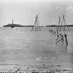
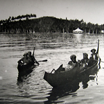
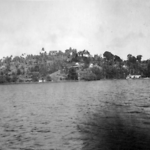
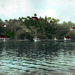
- Title
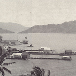
- Gavutu from Halavo, with fishery, Florida (Nggela) Islands (Solomon Islands)
- Type
- Image
- Date
- 1906
- Source
- Anglican Church of Melanesia
.png)
.png)
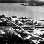
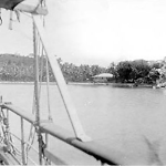
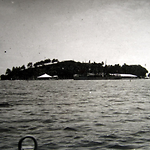
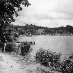
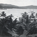
- Title
- Panorama, showing Gavutu and Tulagi, Florida (Nggela) Islands (Solomon Islands)
- Type
- Image
- Date
- 1906
- Source
- Anglican Church of Melanesia
.png)
.png)
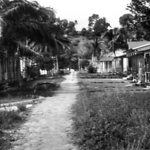
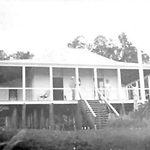
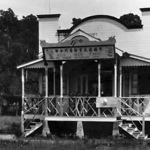
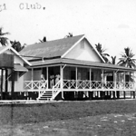
- Title
- Spearline' Wilson's house and the wireless masks, 1930
- Type
- Image
- Date
- 1930s
- Source
- Wilson
.png)
.png)
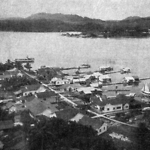
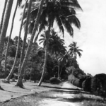
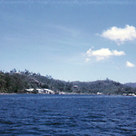
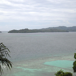
- Title
- View from the Government Residency, Tulagi, 1911
- Type
- Image
- Date
- 1911
- Source
- BSIP Handbook