Place: Ulawa Island
Details
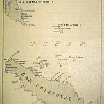
Ulawa Island is located near Small Malaita, just thirty kilometres to the west, and fifty kilometres from Makira Island, which is directly south. It is now included in Makira Province. Ulawa is sixty-six square kilometres and its highest point is 118 meters.
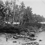
The language of Ulawa is closely related to that of the Sa'a people on the southeast coast of Small Malaita. The Ulawa language is also closely related to those of Ugi ni Masi and the Three Sisters Islands between Ulawa and Makira. The population of Ulawa would never have been large, however we know that there was considerable depopulation during the nineteenth century due to introduced diseases. Rev. Walter Ivens believed that the population in the 1890s was around 1,200, much the same as in the 1959 census, when Ulawa's population was recorded as 1,247. The people form a patrilineal society with alaha (chiefs) determined through primogeniture. Ulawa's people speak of their island metaphorically as a fish, with the northern end its head and the southern its tail. Before they became Christians the Ulawans were shark-worshippers. Guardian sharks kept wild sharks away from the landing places and from traditional territorial sea boundaries around Ulawa. At Su'utaluhia, the ancestral guardian shark is known as 'Sautehi-i-matawa', whose sacred-pool was at Liwe-ni-pa'ewa, (cave for sharks) at the mouth of Aarau River. There, the 'Sautehi-child', formerly a male human child, was incarnated into a shark. Another sacred pool, where Sautehi-i-matawa lived, is at Lopo-ni-mwane at the Hatalea-i-Taluhie, south of Su'utaluhia. Each landing place had its own canoe house (taoha) for the sacred canoes (ta'eolu) used to catch bonito tuna. (Ivens 1927; Hilliard 1978a, 65-66, 171-173; Rohorua 2007, 168-171)
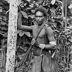
The first Europeans to visit Ulawa were Spaniard Alvaro Mendaña y Neyra and his crew, in 1568. They called the island La Treguada (the Truce), and believed the local name was Uraba. The French explorer Jean-Francis-Maria de Surville named Ulawa as Contrairete Island in 1769 because of the contrary wind systems he found there. In 1568 Ulawans carried bows and arrows as well as spears, whereas by the nineteenth century they used no bows and arrows. The same change had taken place on the northern end of Makira and to some extent at Sa'a on Small Malaita. The Spanish also reported that the Ulawa chiefs wore many shell decorations, and wooden earplugs and combs inlaid with mother-of-pearl. Ulawa was famed for the pearl-shell decorations on its canoes for bonito fishing, which skills they transferred to making church altars once the Anglicans arrived. At feasts Ulawans use large food bowls that can be over four metres long. The finest shell money in the eastern Solomon Islands came from Ulawa, and was known as haa'a-ni-Ulawa. The discs were very small, with as many as fifty to an inch, and were a delicate red, with white-grey shells used on the string ends.
Nearby Makira attracted whalers and traders onwards from the 1830s and 1840s, which suggests there was early, sustained contact with Ulawa at about the same time. There is a reference to trading for coconuts at Ulawa in 1836 (Bennett 1987, 259). Anglican records reveal that in about 1869 a visiting European ship introduced an epidemic of dysentery that killed one-quarter of the population.
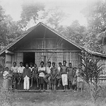
Bishop Patteson visited Ulawa in 1860-1861, taking six youths and two of their young wives back to New Zealand for training. Others were taken to Norfolk Island. Patteson's first real success on Ulawa was with Walter Waaro (q.v.) who left the island in 1870 and returned to found a school there in 1880. The Rev. Walter Ivens (q.v.) was the first European missionary to settle on Ulawa in 1895. He studied the Ulawa-Sa'a language, translated the New Testament into Ulawan and produced a dictionary of the language. Since that time, Ulawa has remained an Anglican stronghold. St. Barnabas' church in Mwadjo'a Village, built from coral rock and limestone between 1901 and 1907 under the guidance of Clement Marau (q.v.), had the distinction of being the largest European-style structure in the Protectorate at that time.
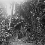
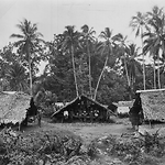
Ivens' 1927 book names the island's nine villages as Su'uholo and Mouta on the east coast, Ahia, Mwarada, Lenga, Ripo, Mwado'a and Haraine on the west coast, and Ngorangora on the northern peninsula. There were also many deserted village sites. Rupo village, at Arona on the west coast, had recently been abandoned, as had Oo'u village south of Su'uholo, the people having migrated to Su'uholo. On the west coast the people lived near the various canoe landing places in scattered hamlets. Amalgamations into larger settlements occurred during the early period of Anglican missionaries. At Mwado'a and Haraina there had been villages on the hills behind, but most villages were near the sea. (Ivens 1927, 42-45)
During the second half of the nineteenth century Ulawan men began recruiting on labour trade ships to Queensland and Fiji. The overseas labour trade began in the early 1870s and continued until the 1910s, by which time Ulawans were also recruiting as workers within the Protectorate. Colonial statistics suggest that Queensland ships recruited 147 Ulawans, mainly men, between 1870 and 1904, and Fiji ships carried away another nineteen. In such a small population, these were significant numbers. (Price with Baker 1976; Siegel 1985)
Once F. M. Campbell (q.v.) opened Kirakira government station on Makira in 1918, Ulawa became one of the eight local districts, each with an appointed 'district chief'. Ulawa became part of Eastern District, which also included Makira, Ugi, Three Sisters, Santa Ana, Santa Catalina and the eastern outer islands of Santa Cruz, Reef Islands, Utupua, Vanikoro, Anuta and Tokopia.
Ulawa escaped most of the turmoil of the Second World War. One coastwatcher, Michael Foster, previously a District Officer for the Eastern Outer Islands, was stationed on nearby Makira to report to the Allies on Japanese troop movements. A constant stream of aircraft flew overhead and naval ships passed by Ulawa. Many Ulawa men went to work in the Labour Corps and the Defence Force at Lungga on Guadalcanal. Because of Ulawans' wartime experiences and their close association with South Malaitans, Maasina Rule (q.v.) also spread to their island in early 1946, and remained important into the early 1950s. The centre of Maasina Rule there was Su'uholo village. After the war, some people left for work in Honiara and other Protectorate centres, attracted by the chance of education for their children. Others sent their children to Anglican schools on Ugi and Makira.
Ulawa was granted its own Local Government Council in 1953. During the 1970s, leaders of the Ulawa Island Council leaders were given the choice of amalgamating with either Malaita or Makira. They chose Makira, with the provision that the name of Ulawa had to be included in the name of the council, and so the new name became Makira/Ulawa Council. Ulawan leaders also asked that the island should have political representatives on that Council, and at the provincial and national government levels, and this was also accepted. Of the eighteen wards of the Makira/Ulawa Provincial Government, three are on Ulawa. At the national level, Ulawa Island joins Ugi Island in forming the Ulawa/Uki (sic.) Constituency. (Rohorua 2007, 179-180, 187-188; Bennett 1987, 14, 112)
Related entries
Published resources
Books
- Bennett, Judith A., Wealth of the Solomons: A History of a Pacific Archipelago, 1800-1978, University of Hawai'i Press, Honolulu, 1987. Details
- Hilliard, David, God's Gentleman: A History of the Melanesian Mission, 1849-1942, University of Queensland Press, St Lucia, 1978a. Details
Journal Articles
- Siegel, Jeff, 'Origins of Pacific Island Labourers in Fiji', Journal of Pacific History, vol. 20, no. 2, 1985, pp. 42-54. Details
Theses
- Rohorua, Frederick Isom, 'The Concept of Development in Ulawa in Solomon Islands and Its Implications for National Development Policy and Planning', PhD thesis, 2007. Details
Images
- Title
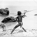
- A Fighting Man of Ahia, throwing Spear, Ulawa Island (Solomon Islands)
- Type
- Image
- Date
- 1906
- Source
- Anglican Church of Melanesia
.png)
- Title
- A Fighting Man of Ahia-Vigt., ¾ face, Ulawa Island (Solomon Islands)
- Type
- Image
- Date
- 1906
- Source
- Anglican Church of Melanesia
- Title
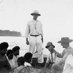
- Bishop Wilson return to the Southern Cross from Ulawa Island, at the steer oar
- Type
- Image
- Date
- 1906
- Source
- Anglican Church of Melanesia
- Title
- Church at Lenga, Ulawa Island (Solomon Islands)
- Type
- Image
- Date
- 1906
- Source
- Anglican Church of Melanesia
- Title
- Church at Madoa-North Side, Ulawa Island (Solomon Islands)
- Type
- Image
- Date
- 1906
- Source
- Anglican Church of Melanesia
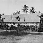
- Title
- Church at Madoa-South Side, Ulawa Island (Solomon Islands)
- Type
- Image
- Date
- 1906
- Source
- Anglican Church of Melanesia
.png)
- Title
- Church at Suholo, Ulawa Island (Solomon Islands)
- Type
- Image
- Date
- 1906
- Source
- Anglican Church of Melanesia
.png)
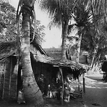
- Title
- Gamal at Ahia, showing Decorated Front, Ulawa Island (Solomon Islands)
- Type
- Image
- Date
- 1906
- Source
- Anglican Church of Melanesia
.png)
- Title
- Hector Raraaba from Suholo, Ulawa Island (Solomon Islands)
- Type
- Image
- Date
- 1906
- Source
- Anglican Church of Melanesia
- Title
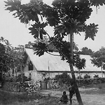
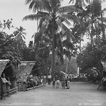
- In the Village of Madoa, Ulawa Island (Solomon Islands)
- Type
- Image
- Date
- 1906
- Source
- Anglican Church of Melanesia
- Title
- In the Village of Madoa, Ulawa Island (Solomon Islands)
- Type
- Image
- Date
- 1906
- Source
- Anglican Church of Melanesia
(.png)
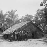
- Title
- In the Village of Suholo, Ulawa Island (Solomon Islands)
- Type
- Image
- Date
- 1906
- Source
- Anglican Church of Melanesia
.png)
- Title
- Inside Church at Madoa, Ulawa Island (Solomon Islands)
- Type
- Image
- Date
- 1906
- Source
- Anglican Church of Melanesia
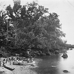
- Title
- Landing-place at Lenga, Ulawa Island (Solomon Islands)
- Type
- Image
- Date
- 1906
- Source
- Anglican Church of Melanesia
- Title
- Man of Ulawa (3/4 figure with bow and arrows), Ulawa Island (Solomon Islands)
- Type
- Image
- Date
- 1906
- Source
- Anglican Church of Melanesia
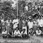
- Title
- Men of the School at Suholo, Ulawa Island (Solomon Islands)
- Type
- Image
- Date
- 1906
- Source
- Anglican Church of Melanesia
- Title
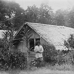
- Missionary's House at Madoa, Ulawa Island (Solomon Islands)
- Type
- Image
- Date
- 1906
- Source
- Anglican Church of Melanesia
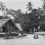
- Title
- School Houses and Scholars, Ulawa Island (Solomon Islands)
- Type
- Image
- Date
- 1906
- Source
- Anglican Church of Melanesia
- Title
- School People at Lenga, Ulawa Island (Solomon Islands
- Type
- Image
- Date
- 1906
- Source
- Anglican Church of Melanesia
- Title
- The Landing-place at Ahia, Ulawa Island (Solomon Islands)
- Type
- Image
- Date
- 1906
- Source
- Anglican Church of Melanesia
.png)
- Title
- The Landing-place at Suholo from beach, Ulawa Island (Solomon Islands)
- Type
- Image
- Date
- 1906
- Source
- Anglican Church of Melanesia
- Title
- Track from landing-place at Madoa, Ulawa Island (Solomon Islands)
- Type
- Image
- Date
- 1906
- Source
- Anglican Church of Melanesia
- Title
- Village Scene at Ahia, Ulawa Island (Solomon Islands)
- Type
- Image
- Date
- 1906
- Source
- Anglican Church of Melanesia
.png)
- Title
- Young Men of Madoa (Group3), Ulawa Island (Solomon Islands)
- Type
- Image
- Date
- 1906
- Source
- Anglican Church of Melanesia