Place: Malaita Island
Details
Malaita has been the most populous island in the Solomon Islands for centuries, certainly back to the sixteenth century and possibly much earlier. Today, there are one hundred and fifty thousand Malaitans on the island and tens of thousands more spread through the nation, particularly in Honiara. Solomon Islanders of Malaitan decent make up more than one-third of the country's population. (Bougainville (q.v.), the largest of the Solomon Islands, now part of Papua New Guinea, carries a similar size population.)
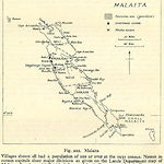
Malaita is an elongated continental island with a high central spine. The island covers 4,200 square kilometres spread over a land mass 190 kilometres long and 10-40 wide. Its rugged central mountains commonly rise above 1,000 metres and to 1,430 in the south, dissected by razor-backed ridges and deep valleys that make travelling even short distances an ordeal for most Europeans. The closest islands are Guadalcanal, which is larger (5,336 square kilometres), higher (2,450 metres) and wider and has a significant flat plain on its northern side (460 square kilometres). Malaita's only substantial flat area is around the Aluta basin on the central east coast.
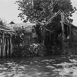
Malaita is actually two islands separated by the narrow, winding Raroisu'u (Maramasike Passage), which at its western end is no wider than a large river, then spreads out to encompass a sheltered mangrove-shrouded waterway which meanders east. The southern island is called Small Malaita or its local language equivalent, Maramasike. The central mountains combine volcanic ridges with limestone-rich karst lands, and are flanked by hilly plateaux, hills and narrow coastal terraces interspersed with valleys and swamps. Most of the coastline is made up of low terraces broken by river valleys, but on the east coast, high karst plateaus extend to the coast and the descent is often precipitous. Extensive shallow lagoons bound by outer reefs stretch along the northeast (Lau Lagoon), central west (Langalanga Lagoon) and southwest coasts ('Are'are Lagoon) and, with the Maramasike Passage, provide a sheltered haven from sometimes harsh seas. The lagoons and the mangroves swarm with fish. Some lagoons are lake-like in appearance, while others are long narrow fringing strips, with openings through reefs to the open sea and bare patches at low tide. Malaitans have constructed artificial islands in the lagoons made from coral rock laboriously collected on rafts. (Parsonson 1966, 1968; Chowning 1968; Tedder 1968) Adjoining areas of the coast that were once also part of lagoons are often swampy
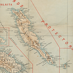
Indispensable Strait to the southwest of Malaita separates the island from Nggela and Guadalcanal. Isabel is to the northeast, Ulawa is to the east opposite Small Malaita, and Makira is directly south. People in the south of the main island (the 'Are'are) are closely connected to the inhabitants of Small Malaita, Ulawa and Makira through language, custom and trade. Those along the west coast have close ties to Guadalcanal and Nggela, and there is an 'Are'are colony at Marau Sound on Guadalcanal. (Coppet 1977; Scott 2007; Ouou 1980)
As with neighbouring Guadalcanal and Isabel, it seems possible that there was never one name for Malaita. If there was, it was Mala, with some small local variations. 'Mala' is used in the north, but further south the word becomes 'Ngwala', 'Mara' and 'Mwala'. It was first called 'Malaita' or 'Malayta' by Spanish explorers in 1568, which is thought to have been a misunderstanding. When they pointed to the island and asked what it was called, the people of neighbouring Isabel Island are supposed to have said 'Mala eta': that is, 'Mala over there to the east'. (Woodford 1926, 482) Some early sources also use 'Malanta', 'Maratta' or 'Mahratta' as variants on Malaita. Perhaps Mala was the name used in Isabel to describe the north of the island. Mala's people were known as 'Maratta' or 'Mahratta' when they worked on sugar plantations in Queensland during the nineteenth century, derived from a pronunciation from one of the southern language areas. Small or South Malaita is also known as Sa'a, or Maramasike Island, and the main island was also called Mala Paina ('large Malaita'). Gallego from Mendaña's 1568 expedition called Mala, Isla de Ramos (Island of Palms) because they first saw the island on a Palm Sunday morning.
There was no single Malaitan identity, although there is unity in their origins, which appear to be Austronesian migrations from the north between 3,500 and 5,000 years ago. The oldest of the Malaitan descent groups now claim more than twenty-five generations, arrived at by telescoping early generations. The Kwara'ae often claim that their ancestors were the island's original settlers. Some To'aba'ita claim that at Foo'odo in the north there are old ruins of substantial stone fortifications which they assert show their ancestors to have been the first arrivals. (Daefa, Lost Temple video; Timmer 2008, 2011a, 2011b)
There are many different Malaitan language groups whose members today may interact as Malaitans, while still maintaining a primary identity with their own region and its cultural mores. There are eleven languages and many dialects: To'aba'ita is located in the far north, then, moving south, five languages cut consecutively across the island: Baelelea, Baegu, Fataleka, Kwara'ae and Kwaio. To'aba'ita, Baelelea, Baegu and Fataleka are closely related. 'Are'are also cuts across the island and occupies the largest geographic area, in the south of the main island and onto Small Malaita, and Sa'a covers the remaining, southern part of Small Malaita. There is also the Langalanga language in the lagoon off Kwara'ae and Kwaio on the west, the Lau language stretching down the Lau Lagoon in the northeast, and Gula'ala'a, an east coast language centred on Kwai and Ngongosila islets off east Kwara'ae that stretches from Lau Lagoon to South Malaita. It contains aspects of all of the languages with eastern coastal zones and in places served as a trading language. There were always links between languages created by colonies. Examples are the people around Walande on Small Malaita who are closely related to the northern Lau and speak the Lau language, the relationship between Sa'a and Ulawa, and the 'Are'are colony at Marau on Guadalcanal. The greatest differences are apparent between the languages of the south and those of the north. There are also many dialects, for instance the Kwaikwaio dialect of Kwaio in the southeast between Kwaio and 'Are'are, and Dorio (or Kwarekareo) in the southwest, which is a much more distinctive mix of Kwaio and 'Are'are.
Malaitans first experienced foreigners from outside the Pacific Islands in 1568. On Palm Sunday, 11 April, Mendaña's expedition sighted the island from neighbouring Isabel Island. A brigantine left the other ships at Port Cruz (now Honiara) on Guadalcanal and set off south, coasting past small Rua Sura Island and on to Marau. The ship reached Malaita on 25 May and entered 'Are'are Lagoon at Rohinari (Uhu Passage), which they named Hidden Harbour (Porto Escondido), then sailed along the coast, anchoring at Ariel Bay, which they called Port Ascension. These Spanish visitors also called at large Su'upaine Bay, a short distance from Cape Zelée, the southernmost point of South Malaita. Attacked at Uhu by twenty-five canoes, the Spanish returned fire with their arquebuses, killing and wounding some people. At Ariel Harbour, faced with a crowd of two hundred, there was no close interaction, and at Su'upaine there was another altercation dispersed with guns. As with many early exploratory visits to Pacific Islands, it is difficult to know if there were any lasting consequences. Anthropologist Daniel de Coppet believed that a memory of the visit remained as epidemic disease that spread from the contact, although this memory could have stemmed from later visits by others (Coppet 1977). Reading the Spanish evidence, one is struck by the lack of fear shown by Malaitans and other Solomon Islanders when confronted by the strange foreigners.
After the Spanish visit, Malaitans had occasional contacts with Europeans. In 1767, Philip Carteret, commanding HMS Swallow, seized eight or ten occupants of a canoe near Da'i Island off Malaita's northwest end. Two years later, Jean-François-Marie de Surville on St Jean-Baptiste passed east of Malaita, but well out to sea. The next contact was probably a quarter-century later, in 1790, when Lieutenant Ball sailing from New South Wales travelled north along the east coast of Malaita. In 1792, Recherche and Espérance commanded by Bruny d'Entrecasteaux and in search of La Pérouse, sailed close by south Malaita. (Woodford 1909a, 506; Spate 1988, 95-98, 116-119)
Once the British settled Botany Bay in New South Wales in 1788, many merchant vessels began to use a route to Asia that passed just east of the Solomon Archipelago. (D'Entrecasteaux 2001, map 4, 89; Spate 1988, 92-94; AR 1971, 113) Soon after, with the Atlantic whaling ground in decline, whalers began to ply their trade in the islands. Malaitans would have seen ships sailing past east Malaita when skirting the Solomons, or travelling through Indispensable Strait on Malaita's west side. While landings were rare, the ships were visible and canoe traffic from Malaita to Guadalcanal, Nggela, Makira and Isabel would have come into contact with these foreigners. Naval vessels, such as Captain Erskine's HMS Havannah in 1850, also patrolled surrounding waters. This ship called at Port Adam on the east coast of Small Malaita between 21 and 24 September 1850, and edged its way into the unknown bay. Two descriptions of the visit have survived, by Charles Moore and Philip Vigors. (Vigors 1850, 202)
Malaitans were not part of the whaling and trading networks that began to develop in the Solomons around the 1800s. These new networks intensified in the 1820s, and whaling voyages peaked in the 1840s and 1850s. Malaitans must have been very frustrated by their inability to get iron and tools and weapons through trade with Europeans. Apart from prestige value, access to iron greatly reduced men's workloads; their tasks such as clearing gardens and building boats and houses were accomplished more quickly, releasing them for other tasks or allowing them to produce more with the same effort or amount of time. This may have enabled more time to be spent on leisure, fighting or trading. The influx of iron onto nearby islands meant that communities near whaling ports prospered and long-established trade patterns and hierarchies began to change. Malaitan shell and porpoise-teeth currencies had for generations been important trade items linking Malaita to the surrounding islands, and 'Are'are and Sa'a had dominant links with Makira. But starting in the 1840s Makira Harbour developed as a whaling port and soon Makirans had the upper hand since Malaitans had nothing valued by whalers and traders. Malaita's lagoons were numerous but not commodious, its warlike reputation made Europeans wary, and Malaita's strict sexual codes meant that no women were available to satisfy the lusts of the crews. Aside from contact with a few castaways and occasional passing trading or whaling ships seeking supplies of wood, water and food (which were often attacked to obtain European goods), Malaitans remained outside the spread of European influence into the Pacific. (Corris 1973b, 6-23; Bennett 1987, 21-44; Moore 1985, 33-36) They seem to have made little effort to enter into trade, although they would have received small supplies of European goods via Makira and Isabel.
Based on Judith Bennett's detailed analysis of the logs of whaling ships, the vessels began to sail close to Malaita onwards from 1799 and by the 1820s there were some limited direct contacts between the crews and Malaitans. (Bennett 1987, 30-31, 350-355) There is one possibly exaggerated report of a shipwreck off north Malaita in the 1820s, after which twenty men were eaten and only one man survived. (Smith 1844, 203-206) More certainly, a ship's captain was killed and his second officer kidnapped in north Malaita in 1827, and other ships were involved in disturbances. The earliest European resident on Malaita was known as Doorey or Matthews, second officer on the whaler Alfred out of Sydney, which was attacked when it reached Malaita in December 1827. Several crew members were killed, and Matthews lived on Malaita for an unknown number of years. (Forster 1975, 97)
The next European resident was John (Jack) Renton (q.v.), a Scottish seaman who was the only survivor among five deserters from the American guano boat Renard in 1868. He and his companions drifted almost two thousand kilometres in one of the Renard's boats, finally landing at Maana'oba Island off the northeast coast. His four companions were killed but Renton became a 'guest' of Lau Lagoon bigman Kabbou and lived from 1868 until 1875 on Sulufou islet.
Anglican Bishop Patteson (q.v.) first visited Malaita in 1856 and in 1866 he took two South Malaitans, Joseph Wate'ae'pule (q.v.) (also known as Wate) and Watehou, to the Melanesian Mission station on Norfolk Island. (Moore 1985, 35) Wate returned and established an Anglican school on Small Malaita in 1879, failed, and then began again in 1884-1886, with final success in 1897. The Mission spread to nearby Port Adam that year, Aulu, Pwaloto, Roas, Pou and Palasu'u in 1898, and then to Pululahu in 1904 and Ariel Harbour in 1907. In northern Malaita, the Mission established its first bases at Fiu in 1898, Foate soon after, Kwarea (Fauabu) in 1903, Laulana in 1904, Bita'ama in 1907 and Maana'oba in 1908. In northeast Malaita, they set up bases at 'Ataa in 1898, Ngorefou in 1902 and Fouia in 1904, and at Uru in central east Malaita in 1905.
Following close on the heels of the Anglicans was the Queensland Kanaka Mission (q.v.), first through Peter Abu'ofa (q.v.) in 1894, then various European missionaries in the 1900s. The Mission arrived formally in 1904, succeeded by the South Sea Evangelical Mission (q.v.) from 1907. The earliest QKM and SSEM bases were in north Malaita at Malu'u in 1894, followed by Sutoti, Tekinana, Gamour, Asimani and Sio in 1905, Maana'oba and Da'i in 1907 and Kwaria and 'Ataa in 1908. The QKM/SSEM spread to east Malaita in the 1900s: to Sinalagu in 1903-1905, Kwai-Ngongosila in 1905, Wunfor, Forti and 'Aioo in 1906, Maanawai and Bedimanu in 1907, Takataka in 1908 and 'Oloburi in 1909. The evangelicals arrived in west Malaita at Onepusu (the SSEM headquarters) in 1902/1905, Laulana, Asimana, Kwari'ekwa, Hauhui and Boronasu'u in 1906, and then Araora, Baunani, Bina, Aineo, Uhu and Baunani (at the Malayta Company [q.v.]) in 1909. The final expansion was to Small Malaita, in direct competition with the Melanesian Mission: to Hauloho and Su'upeine in 1907, and Heohoni, Baibai, Pau and Tawina in 1908. The last of the three early missions to arrive on Malaita were the Catholics, first as an extension of their activities on Guadalcanal in the early 1900s, then purposely in 1908 to take up land to begin a mission at Tarapaina, invited by a bigman named Ara'iasi who had fallen out with the SSEM. The Tarapaina land was purchased in 1911 and purchase extended to Rohinari in 'Are'are Lagoon in 1912.
Malaitan men (and some women) were the dominant Solomon Islander participants in the indentured labour trade to Queensland (9,186 contracts between the 1870s and 1903), to Fiji (5,149 contracts between the 1870s and 1911) and internally in the Solomons (35,596 contracts between 1913 and 1940). (Price with Baker 1976; Siegel 1985; Shlomowitz and Bedford 1988; Bennett 1974, 48-72) Between the 1870s and 1940s indentured labour was being drawn off Malaita, thousands leaving each year on indenture contracts. The 1870s were a time of illegal practices, although by the end of the decade there were Malaitans making their second trip, and though the labour system remained exploitative, a clear transition to volunteerism occurred. As the labour trade progressed from the 1870s, a primary motivation for Malaitan participation became to get steel tools and, increasingly important, firearms. The first guns were unreliable muzzle-loaders, but the more powerful and accurate rifles increasingly became available. These were used to defend and advance the interests of different groups that jockeyed for power and to defend against raiders from further north. As power balances between descent groups shifted, some bigmen, such as Kwaisulia in Lau, gained unprecedented levels of power.
The government established a headquarters in 1909 at Rarasu, mis-named for the island of 'Aoke, and misspelt that name as Auki (q.v.), which has become the conventional spelling used here. While Auki was being established during the 1910s, the three Christian churches already operating, a large plantation venture underway, and the Malayta Company (q.v.) at Baunani all made a big impact. This substantial Christian presence meant large changes occurred on Malaita, a local extension of the changes already brought by the external labour trade since the 1870s. Malaita never had many plantations, with the largest at Baunani, until the company shifted its focus to the Russell Islands in 1918, and others created before the Second World War at Mamnaba and Fulo, both close by Baunani, and at Su'u.
On 22-23 January 1942, and then continuing through March and April, the Japanese bombed Gavutu and Tulagi, which forced a hurried evacuation to Auki, and after heavy air raids on 1 and 2 May Tulagi fell on 3 May. On 4 May, High Commissioner William Marchant (q.v.) evacuated from Auki to Fulisango in the hills behind, joined by Anglican and Catholic bishops. The Japanese landed at Fauabu, where they remained until November and they visited Auki, looting the town. There were also some bombing raids in Langalanga Lagoon and east 'Are'are, although these may have been by the Allies. Once Guadalcanal was recaptured, as early as late August 1942, Martin Clements, a Protectorate officer who had become a coastwatcher (q.v.), was instructed by the Resident Commissioner to resume his duties as District Officer of Guadalcanal. By 2 September the Resident Commissioner had moved to Lungga and accommodations were worked out between the Allied forces and the Protectorate Government. (Baddeley 1942; Trench 1956)
After the Second World War, Maasina Rule (q.v.), a proto-nationalist movement began on Malaita and dominated the political and economic affairs of the island from 1946 to 1952. Two results were the opening of King George VI School (q.v.) and the formation of the Malaita District Council (q.v.).
Related entries
Published resources
Books
- Bennett, Judith A., Wealth of the Solomons: A History of a Pacific Archipelago, 1800-1978, University of Hawai'i Press, Honolulu, 1987. Details
- Corris, Peter, Passage, Port and Plantation: A History of Solomon Islands Labour Migration, 1870-1914, Melbourne University Press, Melbourne, 1973b. Details
- D'Entrecasteaux, Antoine Raymond Joseph de Bruni, Bruny d'Entrecasteaux: Voyage to Australia and the Pacific, 1791-1793, Edward Duyker;Maryse Duyker, Miegunya Press at Melbourne University Press, Melbourne, 2001. Details
- Moore, Clive, Kanaka: A History of Melanesian Mackay, Institute of Papua New Guinea Studies and the University of Papua and New Guinea Press, Port Moresby, 1985. Details
- Ouou, Emulio-Ree, History of South Malaita, Origins of Livings, Centre and Diameter of the Universe, Emulio-Ree Ouou, Honiara, 1980. Details
- Scott, Michael W., The Severed Snake: Matrilineages, Making Place, and a Melanesian Christianity in Southeast Solomon Islands, Carolina Academic Press, Durham, Nth. Carolina, 2007. Details
- Smith, Thomas W., A Narrative of the Life, Travels and Sufferings of Thomas W. Smith, Wm. C. Hill., New Bedford, MA, 1844. Details
- Spate, O.H.K., The Pacific since Magellan: Paradise Found and Lost, vol. 3, Australian National University Press, Canberra, 1988. Details
Book Sections
- Timmer, Jaap, 'Kastom and Theocracy: A Reflection on Governance from the Uttermost Part of the World', in Sinclair Dinnen;Stuart Firth (ed.), Politics and State Building in Solomon Islands, ANU E- Press and Asia Pacific Press, Canberra, 2008, pp. 194-212. Details
- Timmer, Jaap, 'Visualising the Lost Temple and Mapping a Straightening World in Solomon Islands: Two Cultural Products of the Deep Sea Canoa Movement', in Carole M. Cusack;Alec Norman (ed.), Handbook of New Religious and Cultural Production. Brill Handbooks on Contemporary Religion, Brill, Leiden, 2011a, p. in press. Details
- Timmer, Jaap, 'Straightening the Path from the Ends of the Earth: The Deep Sea Canoe Movement in Solomon Islands', in L. Manderson;W. Smith;M. Tomlinson (ed.), Belief Beyond Borders: Faith, Migration and Symbol in Asia and the Pacific, Springer Publishing Co., Dordrecht and New York, 2011b, p. in press. Details
Journal Articles
- Chowning, Ann, 'The Real Melanesia: An Appraisal of Parsonson's Theories', Mankind, Official Journal of the Anthropological Societies of Australia, vol. 6, no. 12, 1968, pp. 641-652. Details
- Coppet, Daniel de, 'First Exchange, Double Illusion', Journal of the Cultural Association of the Solomon Islands, vol. 5, 1977, pp. 23-39. Details
- Forster, Honore, 'A Sydney Whaler 1829-32: The Reminiscences of James Heberley', Journal of Pacific History, vol. 10, no. 2, 1975, pp. 94-104. Details
- Parsonson, G.S., 'Artificial Islands in Melanesia: The Role of Malaria in the Settlement of the Southwest Pacific', New Zealand Geographer, vol. 22, April, pp. 1-21. Details
- Shlomowitz, Ralph, and Bedford, Richard D., 'The Internal Labour Trade in New Hebrides and Solomon Islands, c 1900-1941', Journal de la Société des Océanistes, vol. 86, 1988, pp. 61-85. Details
- Siegel, Jeff, 'Origins of Pacific Island Labourers in Fiji', Journal of Pacific History, vol. 20, no. 2, 1985, pp. 42-54. Details
- Tedder, James L.O., 'Artificial Islands Re-Examined', New Zealand Geographer, vol. 24, no. 2, 1968, pp. 186-189. Details
- Trench, D.C.C., 'Marchant on Malaita', Corona, vol. 8, no. 5-7, 1956, pp. 5:106-108, 6: 230-233, 7: 258-261. Details
- Woodford, Charles M., 'The Canoes of the British Solomon Islands', Journal of the Royal Anthropological Institute of Great Britain and Ireland, vol. 39, July-December, pp. 506-516. Details
- Woodford, Charles M., 'Notes on the Solomon Islands', Geographical Journal, vol. 68, July-December, pp. 481-487. Details
Manuscripts
- Vigors, Philip D., Private Journal of a Four Month Cruise through Some of the South Sea Islands, and New Zealand in H.M.S. Havannah, (Manuscript copy in the possession of Dr David Akin, University of Michigan), 1850. Details
Reports
- Baddeley, Walter H., Behind It All Is God: the Melanesian MIssion in War-Time. The Bishop's Report for 1942, The Australian Board of Missions, Sydney, 1942, 7 pp. Details
- British Solomon Islands Protectorate, British Solomon Islands Protectorate Annual Reports (AR), 1896-1973. Details
Theses
- Bennett, Judith A., 'Cross-Cultural Influences on Village Relocation on the Weather Coast of Guadalcanal, Solomon Islands, c. 1870-1953', MA thesis, University of Hawaii, 1974. Details
Images
.png)
- Title
- "War and Peace"-Foate Men in Mission Boat, NW Malaita Island (Solomon Islands)
- Type
- Image
- Date
- 1906
- Source
- Anglican Church of Melanesia
.png)
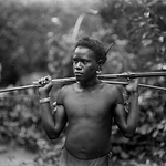
- Title
- A Fiu Guard with Rifle, (Fiu?), NW Malaita Island (Solomon Islands)
- Type
- Image
- Date
- 1906
- Source
- Anglican Church of Melanesia
.png)
- Title
- A Fiu Mission Guard, Men at Foate in Canoe, NW Malaita Island (Solomon Islands)
- Type
- Image
- Date
- 1906
- Source
- Anglican Church of Melanesia
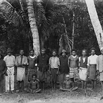
- Title
- A Man of Qarea (3/4 fig.), NW Malaita Island (Solomon Islands)
- Type
- Image
- Date
- 1906
- Source
- Anglican Church of Melanesia
.png)
- Title
- A Man of Uru (3/4 fig.), Kwaio district, Malaita Island (Solomon Islands)
- Type
- Image
- Date
- 1906
- Source
- Anglican Church of Melanesia
- Title
- A Man of Uru (3/4 fig.), Kwaio district, Malaita Island (Solomon Islands)
- Type
- Image
- Date
- 1906
- Source
- Anglican Church of Melanesia
.png)
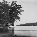
- Title
- A View of Fiu River, NW Malaita (Solomon Islands)
- Type
- Image
- Date
- 1906
- Source
- Anglican Church of Melanesia
- Title
- An Old Man, Ferasiboa, Lau Lagoon, Malaita Island (Solomon Islands)
- Type
- Image
- Date
- 1906
- Source
- Anglican Church of Melanesia
- Title
- Areca Palm Groves, at Saa, Small Malaita Island (Solomon Islands)
- Type
- Image
- Date
- 1906
- Source
- Anglican Church of Melanesia
.png)
- Title
- Boy of Malaita-Vigt, Malaita Island (Solomon Islands)
- Type
- Image
- Date
- 1906
- Source
- Anglican Church of Melanesia
.png)
- Title
- Christ Church, Fiu Mission-Inside, -Outside, NW Malaita Island (Solomon Islands)
- Type
- Image
- Date
- 1906
- Source
- Anglican Church of Melanesia
.png)
- Title
- Christ Church, Fiu Mission-Outside, NW Malaita Island (Solomon Islands)
- Type
- Image
- Date
- 1906
- Source
- Anglican Church of Melanesia
- Title
- Creek Scene, Roas Bay, Small Malaita Island (Solomon Islands)
- Type
- Image
- Date
- 1906
- Source
- Anglican Church of Melanesia
- Title
- Entrance Atta Cove-Abandoned Labour Schooner on the Reef, Malaita Island (Solomon Islands)
- Type
- Image
- Date
- 1906
- Source
- Anglican Church of Melanesia
.png)
- Title
- Entrance to Fiu River, NW Malaita (Solomon Islands)
- Type
- Image
- Date
- 1906
- Source
- Anglican Church of Melanesia
- Title
- Fishing Stands, entrance Bulalaha River, near Maramasike Channel, Malaita Island (Solomon Islands)
- Type
- Image
- Date
- 1906
- Source
- Anglican Church of Melanesia
- Title
- Food Houses at Adegege, Lau Lagoon, Malaita Island (Solomon Islands)
- Type
- Image
- Date
- 1906
- Source
- Anglican Church of Melanesia
.png)
- Title
- Fort in Village of Qarea, NW Malaita Island (Solomon Islands)
- Type
- Image
- Date
- 1906
- Source
- Anglican Church of Melanesia
- Title
- Gamal and Church, Halihan Village, Roas Bay from North, Small Malaita Island (Solomon Islands)
- Type
- Image
- Date
- 1906
- Source
- Anglican Church of Melanesia
.png)
- Title
- Grave of Christian Chief murdered by Bushmen (Fiu Mission?), -Outside, NW Malaita Island (Solomon Islands)
- Type
- Image
- Date
- 1906
- Source
- Anglican Church of Melanesia
- Title
- Group in front of House at Halihau, Roas Bay, Small Malaita Island (Solomon Islands)
- Type
- Image
- Date
- 1906
- Source
- Anglican Church of Melanesia
.png)
- Title
- Group of Bushmen at Foate, NW Malaita Island (Solomon Islands)
- Type
- Image
- Date
- 1906
- Source
- Anglican Church of Melanesia
- Title
- Group of Ferasiboa Men, Lau Lagoon, Malaita Island (Solomon Islands)
- Type
- Image
- Date
- 1906
- Source
- Anglican Church of Melanesia
.png)
- Title
- Group of Fiu Mission Girls, NW Malaita Island (Solomon Islands)
- Type
- Image
- Date
- 1906
- Source
- Anglican Church of Melanesia
- Title
- Group of Foate Women, NW Malaita Island (Solomon Islands)
- Type
- Image
- Date
- 1906
- Source
- Anglican Church of Melanesia
- Title
- Group of Roas Women, Small Malaita Island (Solomon Islands)
- Type
- Image
- Date
- 1906
- Source
- Anglican Church of Melanesia
- Title
- Houses on Ferasiboa artificial island, Lau Lagoon, Malaita Island (Solomon Islands)
- Type
- Image
- Date
- 1906
- Source
- Anglican Church of Melanesia
.png)
- Title
- In the Village of Fiu Mission, NW Malaita Island (Solomon Islands)
- Type
- Image
- Date
- 1906
- Source
- Anglican Church of Melanesia
- Title
- In the Village of Roapu, Roas Bay, Small Malaita Island (Solomon Islands)
- Type
- Image
- Date
- 1906
- Source
- Anglican Church of Melanesia
- Title
- In the Village of Roapu, Roas Bay, Small Malaita Island (Solomon Islands)
- Type
- Image
- Date
- 1906
- Source
- Anglican Church of Melanesia
- Title
- In the Village of Saa, Small Malaita Island (Solomon Islands)
- Type
- Image
- Date
- 1906
- Source
- Anglican Church of Melanesia
- Title
- In Village at Foate, NW Malaita Island (Solomon Islands)
- Type
- Image
- Date
- 1906
- Source
- Anglican Church of Melanesia
.png)
- Title
- Inside Palisade at Nore Fou, showing Village, Lau Lagoon, Malaita Island (Solomon Islands)
- Type
- Image
- Date
- 1906
- Source
- Anglican Church of Melanesia
- Title
- Landing Place at Saa, from the Shore, Small Malaita Island (Solomon Islands)
- Type
- Image
- Date
- 1906
- Source
- Anglican Church of Melanesia
- Title
- Landing-place at Qarea, NW Malaita Island (Solomon Islands)
- Type
- Image
- Date
- 1906
- Source
- Anglican Church of Melanesia
.png)
- Title
- Little Roapu Girl Carrying Child, Roas Bay, Small Malaita Island (Solomon Islands)
- Type
- Image
- Date
- 1906
- Source
- Anglican Church of Melanesia
- Title
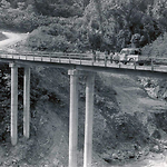
- Mariano Kelesi, Minister for Works and Public Utilities in 1978 inspecting the new bridge in central Malaita Island
- Type
- Image
- Date
- 1978
- Source
- Clive Moore
.png)
- Title
- Men of Bulalaha-Group by the River, near Maramasike Channel , Malaita Island (Solomon Islands)
- Type
- Image
- Date
- 1906
- Source
- Anglican Church of Melanesia
- Title
- Men of Uru-Group of 3, Kwaio district, Malaita Island (Solomon Islands)
- Type
- Image
- Date
- 1906
- Source
- Anglican Church of Melanesia
.png)
- Title
- Men's Landing-place at Ferasiboa, Lau Lagoon, Malaita Island (Solomon Islands)
- Type
- Image
- Date
- 1906
- Source
- Anglican Church of Melanesia
.png)
- Title
- Mission Station, Nore Fou, from Reef, Lau Lagoon, Malaita Island (Solomon Islands)
- Type
- Image
- Date
- 1906
- Source
- Anglican Church of Melanesia
.png)
- Title
- Newly Erected Artificial Island off Nore Fou, Lau Lagoon, Malaita Island (Solomon Islands)
- Type
- Image
- Date
- 1906
- Source
- Anglican Church of Melanesia
- Title
- On the North Shore, Roas Bay, Small Malaita Island (Solomon Islands)
- Type
- Image
- Date
- 1906
- Source
- Anglican Church of Melanesia
- Title
- Outside Palisade, round Nore Fou, Lau Lagoon, Malaita Island (Solomon Islands)
- Type
- Image
- Date
- 1906
- Source
- Anglican Church of Melanesia
.png)
- Title
- People at Adegege, Lau Lagoon, Malaita Island (Solomon Islands)
- Type
- Image
- Date
- 1906
- Source
- Anglican Church of Melanesia
- Title
- People of Qarea, NW Malaita Island (Solomon Islands)
- Type
- Image
- Date
- 1906
- Source
- Anglican Church of Melanesia
- Title
- Roas Bay from North, Small Malaita Island (Solomon Islands)
- Type
- Image
- Date
- 1906
- Source
- Anglican Church of Melanesia
- Title
- Roas Boy Shooting Arrow, Roas Bay, Small Malaita Island (Solomon Islands)
- Type
- Image
- Date
- 1906
- Source
- Anglican Church of Melanesia
- Title
- Roas Boy, ¾ fig., Small Malaita Island (Solomon Islands)
- Type
- Image
- Date
- 1906
- Source
- Anglican Church of Melanesia
.png)
- Title
- Sacrificial Alter at Ferasiboa, Lau Lagoon, Malaita Island (Solomon Islands)
- Type
- Image
- Date
- 1906
- Source
- Anglican Church of Melanesia
.png)
- Title
- Sacrificial Alter at Ferasiboa, Lau Lagoon, Malaita Island (Solomon Islands)
- Type
- Image
- Date
- 1906
- Source
- Anglican Church of Melanesia
.png)
- Title
- Scene near Women's Landing-place, Ferasiboa, Lau Lagoon, Malaita Island (Solomon Islands)
- Type
- Image
- Date
- 1906
- Source
- Anglican Church of Melanesia
- Title
- School People at Foate, NW Malaita Island (Solomon Islands)
- Type
- Image
- Date
- 1906
- Source
- Anglican Church of Melanesia
- Title
- School People of Bulalaha, near Maramasike Channel , Malaita Island (Solomon Islands)
- Type
- Image
- Date
- 1906
- Source
- Anglican Church of Melanesia
- Title
- School People of Uru, Kwaio district, Malaita Island (Solomon Islands)
- Type
- Image
- Date
- 1906
- Source
- Anglican Church of Melanesia
- Title
- Spearing Fish, Roas Bay, Small Malaita Island (Solomon Islands)
- Type
- Image
- Date
- 1906
- Source
- Anglican Church of Melanesia
.png)
- Title
- Street Scene in Women's Quarters, Ferasiboa, Lau Lagoon, Malaita Island (Solomon Islands)
- Type
- Image
- Date
- 1906
- Source
- Anglican Church of Melanesia

- Title
- The Bulalaha River, near entrance, Malaita Island (Solomon Islands)
- Type
- Image
- Date
- 1906
- Source
- Anglican Church of Melanesia
- Title
- The Chief of Bulalaha (3/4 figure), near Maramasike Channel , Malaita Island (Solomon Islands)
- Type
- Image
- Date
- 1906
- Source
- Anglican Church of Melanesia
- Title
- The Chief's (of Bulalaha) Brother (3/4 figure), near Maramasike Channel , Malaita Island (Solomon Islands)
- Type
- Image
- Date
- 1906
- Source
- Anglican Church of Melanesia
- Title
- The Chief's House at Roapu, Roas Bay, Small Malaita Island (Solomon Islands)
- Type
- Image
- Date
- 1906
- Source
- Anglican Church of Melanesia
- Title
- The Mission House, Nore Fou, Lau Lagoon, Malaita Island (Solomon Islands)
- Type
- Image
- Date
- 1906
- Source
- Anglican Church of Melanesia
- Title
- The Southern Cross at Nore Fou, Lau Lagoon, Malaita Island (Solomon Islands)
- Type
- Image
- Date
- 1906
- Source
- Anglican Church of Melanesia
- Title
- Three Generations-Women of Ferasiboa, Lau Lagoon, Malaita Island (Solomon Islands)
- Type
- Image
- Date
- 1906
- Source
- Anglican Church of Melanesia
- Title
- Three Men of Roas Bay, Small Malaita Island (Solomon Islands)
- Type
- Image
- Date
- 1906
- Source
- Anglican Church of Melanesia
- Title
- Uru-An Artificial Island, Kwaio district, East Coast of Malaita Island (Solomon Islands)
- Type
- Image
- Date
- 1906
- Source
- Anglican Church of Melanesia
- Title
- Uru-near view, Kwaio district, Malaita Island (Solomon Islands)
- Type
- Image
- Date
- 1906
- Source
- Anglican Church of Melanesia
- Title
- Village at Foate, NW Malaita Island (Solomon Islands)
- Type
- Image
- Date
- 1906
- Source
- Anglican Church of Melanesia
.png)
- Title
- Women at Nore Fou in Canoes, trading with ship, Lau Lagoon, Malaita Island (Solomon Islands)
- Type
- Image
- Date
- 1906
- Source
- Anglican Church of Melanesia
- Title
- Women of Port Adam in Canoe, Small Malaita Island (Solomon Islands)
- Type
- Image
- Date
- 1906
- Source
- Anglican Church of Melanesia
- Title
- Women of Qarea, NW Malaita Island (Solomon Islands)
- Type
- Image
- Date
- 1906
- Source
- Anglican Church of Melanesia
.png)
- Title
- Young Man of Malaita (sitting), Roas Bay(?), Small Malaita Island (Solomon Islands)
- Type
- Image
- Date
- 1906
- Source
- Anglican Church of Melanesia
- Title
- Young Men of Ferasiboa (group 2), Lau Lagoon, Malaita Island (Solomon Islands)
- Type
- Image
- Date
- 1906
- Source
- Anglican Church of Melanesia
.png)
- Title
- Young Women (group 2) (Fiu Mission?), NW Malaita Island (Solomon Islands)
- Type
- Image
- Date
- 1906
- Source
- Anglican Church of Melanesia